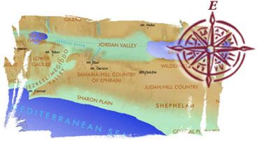
 Our east-oriented maps of the Holy Land are consistent both with the
biblical data and with the way people in the land oriented themselves geographically
throughout their history.
Our east-oriented maps of the Holy Land are consistent both with the
biblical data and with the way people in the land oriented themselves geographically
throughout their history.
The four directions of the compass (north, south, east, and west) are concepts that are
foreign to the Bible. The Bible, however, does have its own compass. Instead of north,
south, east, and west however, it uses different terms to help people orient themselves in
the land. It calls the north "tsaphon," which literally means
"toward the hidden region." It refers to the south as "negeb,"
the region of the Negev. The Negev was the southernmost border of the land promised to
Abraham and his descendants. The west is called the "'am," referring to
the Great Sea, which we know as the Mediterranean. Finally, the east is called the "qedem,"
which means the region in front. Each of these four terms all occurred in Gen 13:14-15 in
which Yahweh promised to give the land to Abraham and to his descendants.
"And Yahweh told Abram after Lot had left from him: ‘Lift up your eyes and
see from the place you are standing to the hidden region (tsaphonah), and to the
Negev (negebah), and to the in front (qedemah), and to the sea ('amah);
because all this land you are seeing to you I will give and to your offspring
forever.’"
— Literal translation from Hebrew
The Bible refers to the east as the place where the sun rises and the west where the
sun sets (Ps 103:12). The south is also called the "region of the right hand"
and the north "region of the left hand." Jacob named the last of his twelve
children Benjamin, which means "son of the right hand" or "son of the
south." Benjamin was born in Bethel, which is located in the south in contrast to the
other eleven who were born in the north (Gen 35:16-18). After entering the land, the tribe
of Benjamin was given a southern region of the conquered land (Josh 18:11-20).
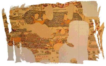 |
The Medeba Map (565 B.C.) |
Throughout post-biblical history, people in Israel mapped their land with an
east-oriented map. The oldest map that has been found is the map of Medeba dated about 565
B.C. It is a mosaic formed by over two million colored stone cubes. The Medeba map is an
east-oriented map depicting the city of Jerusalem in the foreground and the Jordan River
flowing from the left into the Dead Sea on the right in the background.
A series of other maps dating from eleventh, twelfth, and sixteenth centuries such as
Breydenbach’s map of the Holy Land from 1486 B.C. show the Sea of Galilee on the left
and the Dead Sea on the right with the holy city on a prominently high place (These maps
are available for viewing at the Jerusalem in Old Maps and Views
website).
Finally, we have chosen to orient our maps eastward for the practical reason that they
fit better on the computer screen. A north-south map would not fit on the screen. This
would require the user to scroll up and down to view the whole map.
The purpose of this website and CD-ROM is to place you in the footsteps of the people
who walked the land of the Bible. We recognize that our east-oriented maps are unusual and
may be difficult to view at first, but as you become accustomed to them, they will help
you understand the Bible and its people in a different and more meaningful way. This is
what you see when you…